


The first photo is on Lando Cain Road southbound where it transitions into East Byrd Road via a 90 degree turn. This atrocity is what you see as you come up to that dangerous turn. A street name sign is posted on top of the curve sign for a particularly confusing experience. Additionally, a single off-center chevron with the curve sign in the middle of the sharp turn are all that greet drivers. There should either be at least two chevrons visible from each direction or large arrow signs (W6-6). Westbound in the second photo only a (very incorrectly designed) curve sign is posted. As to the curve signs, this appears to be a contractor purchase that wasn't inspected to make sure that what they were buying was MUTCD-compliant. Granted you could shoot into either driveway if you miss the curve, but most drivers would be close to highway speed before being surprised by the severity of this curve an otherwise arrow-straight road. Because of that, the risk of hitting a car coming from the other direction is pretty high (Photos from Google Street View, June 2014).

This is the intersection in question from Google Maps
The issues with the signs are quite numerous. Extremely poor traffic engineering is the tip of the iceberg. The design of nearly every warning and regulatory sign is completely wrong, maintenance is poor, post height is incorrect and what signs exist are rather sparse. Furthermore, county routes still appear on maps, but signage has completely disappeared even though these county routes have not been assigned or posted with names. Street name signs also do not meet MUTCD standards and do not include cross-street names meaning traffic coming from a side road will need GPS to even know what road they are approaching. How can a county that otherwise has smooth, well-built roads have such poor management of traffic signs? This is the county paradox, and this is why safety improvements as a whole are something that should typically not be handled from an individual county or municipal level with exception to a few high income, high population areas. Reason would say that you would be punishing the ones that do it right, but clearly self-policing does not work, and if those "good ones" know something that this county does not, then that knowledge needs to be shared in a way that changes are permanent and for the better.


These winding road signs are just two examples of poorly designed signs pandemic around the county. Both are atrociously designed and do not comply with the MUTCD located on County Road 55: a major collector road. Note that the post height is less than 5' on the first sign and that both signs are 24" x 24" on a major road with a 45 MPH speed limit (both signs are required to be 30" x 30"). Also note that the road curves to the left. This is actually a left reverse curve, not a right winding road. The second sign was witnessed in other counties suggesting a contractor that was not properly vetted for compliance. The first image is on CR 55 eastbound west of Fowler Road and the second on CR 55 westbound west of Chambers Ln (Google Street View, September 2013).

Curve in question on Google Maps. It's fairly obvious from here it is a left reverse curve not a "winding road".
It should be noted that this county does have an engineer, and this engineer clearly has no interest in this aspect of the county road system. However, is this engineer a PTOE? Alabama has provided county engineers, but nobody like this for traffic control. Otherwise, it would be much better. Obviously no traffic study has been conducted on any of these roads or there would be advisory signs under the curve signs, signs would be posted at the correct height, signs would be in the correct place and the signs would look like standard signs. If nothing else, an engineer's right to oversee any county road system when funded by the state should rest on the engineer's compliance with state standards for safety improvements, but preferably the county engineer should not be wearing "many hats" with something like traffic control being a side job, which is clearly what is going on here. Clearly Alabama has no mandate that counties and cities follow these standards despite providing ample funds for this purpose. Since Morgan County was not a captive county, there was also never at any recent time any state help to upgrade these signage deficiencies. To fix this problem, it would be best to be handle this problem from a state level or regional level. Could it be fixed from a local level? Partially, but it's doubtful that the efforts would be enough to truly correct the issues. It did appear some newer signs were more compliant, but that's not enough.
WHAT THE STATE SHOULD DO
It is very clear that Alabama needs to change its approach to county roads. With counties and cities unwilling to consistently and effectively engineer and maintain roads, a greater state role is needed. According to "Implementing the High Risk Rural Roads Program by the FHWA" on page 16 it states, "Alabama trained county engineers in data analysis and low-cost safety improvements. Alabama dedicates all HRRRP funding to qualifying municipal and county roadways. In the first year Alabama divided available HRRRP funds equally among the State’s 67 counties as they developed a specific procedure. In coordination with relevant stakeholders, including local agency representatives, ALDOT developed a process requiring county engineers to participate in data analysis and low-cost safety improvement training to qualify for funding." If that is so, then why aren't the traffic signs in far better shape? This Alabama approach isn't requiring them to do anything or show any results. This program didn't really require any real changes at all. A few small areas look to have been improved, but no major changes have been made with this program. It also appears that Alabama has not really worked to identify these issues on a state level meaning it's up to the counties to regulate themselves. In addition, the lack of a "qualified vendors list" for traffic signs does not provide any means for local agencies to screen private vendors. Many other states have this, including Georgia. These counties by and large appear to have used this funding for other issues not related to traffic control devices. Neither are any quality controls in place for those local agencies assigned with this task to assure that the best materials are being used.


Community Lane just west of Gum Springs Road in the northern part of the county did not disappoint with terrible signs. The Stop Ahead sign and the reverse turn sign both have undersized, incorrect symbols on posts only about 2' off the ground. While the conditions are correct, the signs are not. The reverse turn sign should also have an advisory and either chevrons or arrows on the turn ahead (which it does not). (Google Street View, June 2014)
A start would be for Alabama to carbon-copy Georgia's "Off-System Safety Improvement Program". This program requires little to no local investment, demands state standards are followed, uses state forces to identify problem areas and takes this work out of the hands of local engineers. Some GDOT districts have also hired private engineering firms to conduct traffic studies for these safety projects meaning that roads in many, many counties that have never before had any traffic study nor were in compliance with MUTCD standards have been able to have their safety issues corrected to where they meet or exceed standards found along state highways. By privatizing the process, Georgia took the work out of the hands of counties who were not doing the job right. While Georgia's county road agency structure is different from Alabama's, the state finally understood that technical issues are best addressed outside the scope of local politics at least for the purpose of distributing federal funds for safety improvements. Georgia's approach by no means has been a cure-all nor has it necessarily corrected local maintenance deficiencies after projects are completed, but it gives local governments a chance to do something well that they were unable to do very well before by showing them how to do it the right way and making sure that funds are spent in a way that brings local signage into compliance with state and federal standards. How well these are ultimately maintained in the future, however, remains to be seen as currently no structure is in place to provide statewide or regional traffic control services to local governments. This latter situation is quite similar to Alabama, but the former situation has placed Georgia well ahead of Alabama.


South Cedar Cove Road transitions to North Cedar Cove Road in what is a sharp turn even less than 90 degrees. With that much of a hazard, the only thing posted is an undersized and non-standard turn sign (no advisory) and two chevrons stacked at one point in the curve. If nothing else, large arrows should be stacked and better warning signs should be posted.

The curve in question from Google Maps
In addition to centralizing federal-aid funding, the best strategy by far is the development of a regional traffic control district. This can either be a decentralized model based on planning regions or a centralized one that operates as a local arm of ALDOT.
Regional Traffic Control District: Planning Region Option
The first option is to take traffic control out of the hands of the county engineer and replace it with a more centralized program where traffic engineering is a multi-jurisdictional operation jointly funded by multiple counties and cities across a larger region. It is important to note that the region is very rural and that by itself that Morgan County would still not have adequate population coupled with its own planning region (North-Central Alabama Regional Council of Governments), but if combined with the NW Alabama Council of Local Governments, this would bring the region up to eight counties with a population exceeding 500,000. Could Morgan County then afford a PTOE? Of course. If every county and city participated, the cost of a PTOE would be less than $10,000/year for Morgan County alone! The idea is that a regional traffic control operation separates that responsibility from the county engineer so that resources can be pooled enough to fund an agency whose sole purpose is traffic control planning and maintenance. Clearly the county is not able to do it alone, but when coupled with so many other cities and counties, a benefit that was lost when the "captive county" program was eliminated will not only be given to Morgan County, but will return to five of the counties in the region that used to be part of the captive county system up until 1979.
This top-down approach would create an umbrella regional agency operating as a superlocal division of state government whose sole responsibility is traffic control for multiple counties and cities large and small allowing resources to be pooled to a point that a "state within a state" would replace ineffective and substandard traffic control like this. However, the fact that such an approach is untested means it will be difficult to establish. Will a bunch of neighboring counties be willing to share a service like this? This is why this was not offered as the only strategy.

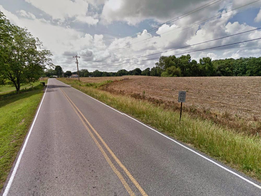
Nearby to Cedar Cove Road, Gum Springs Road has this infamous combination of speed limit doubling as advisory sign and curve sign screw-up like what was seen on County Road 55 (Google Street View, June 2014).
Regional Traffic Control: State-Administered Option
Another option to consider would be using the state government to make this happen. This can be done one of two ways:
- The Contracting Method: An individual county or city basically pays a fee to ALDOT to have the state administer their local traffic control program.
- The Statewide Cooperative Method: The state legislature or state DOT sets up an umbrella agency separate from ALDOT where local agencies pool resources to provide statewide oversight of local traffic control by becoming "members"
Both plans in the second option have in common an operations fee, but on either plan the state can finance the operations alone and can thus waive the fee allowing poorer counties to avoid any excess costs to fund professional services. In the planning region option, the operations fee cannot be waived, because the operations are self-funded by every member local agency. In contrast, the state-administered option has the operations fee dictated by ALDOT with the fee used to add on any necessary employees, equipment or facilities to the existing state operations. Any additional funding provided by the local agency must be returned in kind by the state in labor and materials. The second plan is basically functions like a bank in that each participating local agency is a member and deposits money that can only be used on their roads. However, this "bank" has an operations fee which is used to finance facilities, equipment, staff engineers and other employees whose sole purpose is to plan and maintain traffic control on local roads in all member counties and municipalities. If the state decides it is able to cover it, that would remove all barriers to poorer rural counties, right? ALDOT would not own this agency, but would be provided some regulatory oversight. The second option would most likely require the creation of an elected position to keep the activities of the cooperative accountable to the voters.
On Option 2, the important thing to consider is the potential for permanence in such a situation. Would the state commit to this plan long term or ax it when the budget got a little too tight? The cooperative model is more stable, because it operates outside the realm of ALDOT or the legislature. In addition, the idea with either plan is not to shun the private sector. For instance, in the ALDOT plan the strategy would most likely be that the state plans all traffic control and requires local agencies to purchase from a list of qualified private vendors pooling resources for any large purchases. The state may provide certain materials at a price to the local agencies such as guide or route signs, but the majority of signing materials would come from private vendors.

What drivers actually see approaching a long S-curve with a hidden intersection in the curve on County Road 55 eastbound approaching Patton Rd. (Image from Google Street View, June 2014)


What drivers should be seeing. The signs in this image were added to the street view image slightly further west. Advisory speeds were not included in this image since it is unclear what they would be if used. A W16-8 street name sign was included underneath the W2-1 cross road sign for Patton Road and Moses Road so that drivers would not have to slow down to read the street names in a curve. Yellow "signposts" were used to make them more visible in the image. A close-up of the W16-8 sign is shown here for better visibility.

Here is the area shown on Google Maps.

Here we have OZ Davis Road east of Old Eva Road. A local connecting road, it has a very sharp reverse turn with no signs whatsoever approaches travelers westbound at the end of a 3/4 mile bee line. Having an appropriate independent engineering study would locate and correct missing signage like this. Since no speed limit is posted, this is essentially a basic speed law road. (Google Street View, June 2014).

Area in question along OZ Davis Road. The trailers visible in the Street View image above are in the lower middle of the aerial image for reference.


In another case here, a dangerous curve with a hidden intersection passed it is noted on Nat Key Road and not even marked at all. The latter image took the Street View image and added appropriate warning signs designed to be at proportionally correct heights. Some specific ALDOT standards were incorporated as well such as the object marker under the arrow sign and the oversized advisory speed sign. The yellow posts are not specifically ALDOT standard, but are used to show how these could be yellow-painted for greater emphasis. (Google Street View, June 2014).

Aerial image from Google Maps showing the sharp curve and intersection as shown above. The image is just east of the sharp curve on Nat Key Road with Gibson Road in the middle.
Summary of the Two Plans
In all options, the county's direct involvement in planning, designing and installing traffic control devices is eliminated, but this does not necessarily mean local funding is eliminated. What changes is the management of the devices entrusting it to authorities better trained and suited to handle such matters with a more disciplined approach to engineering standards. It is clear from these images that enforcement of MUTCD standards is not a priority for the state, but if the responsibility was centralized to a certain point, it would create conditions where instead of the liability falling on the county or state, it would fall directly on a licensed PTOE whose career is on the line if the signs are not designed and maintained correctly. This is the only enforcement mechanism, and this needs to be done: traffic control should be placed with an authority whose SOLE PURPOSE is traffic control and who has a vested interest in making sure it is handled the correct way every single time. Morgan County is not doing this, and apparently they have little vested interest in the quality or consistency of traffic control. Unfortunately Morgan County is one of many counties and municipalities across the nation with this attitude. Public safety is simply not important enough to invest heavily in traffic control, and part of that is that nobody on a county level seems to understand the problem well enough.

County Road 55 in Eva has this completely incorrect speed limit sign in Series B. Eva is a city, but mostly contracts road maintenance to the county.


County Road 55 east of Nat King Road has yet another Series B speed limit sign that appears to be 1 foot too low considering the sign is down slope from the pavement. The original and then the correction (fake) is posted just below it. (Google Street View image, June 2014).
The above sign, also on County Road 55, is even worse and is in disrepair. It is located west of Union Hill Church Road. Except in the instance of a kangaroo court, this sign cannot even be enforced if found to be defective, because it is not considered a traffic control device.

The last one is the worst one. Not only is the speed number smaller than the words "SPEED LIMIT" but the sign is also barely two feet off of the ground. This one is located on Indian Hills Road north of Bethel Road in the NW part of the county.


Bridge rail issues are pretty typical in low budget states with a poor safety investment. While an interesting historical novelty, it should be pretty clear from the damage on both rails that these antiquated designs pose a serious hazard to motorists. The two safety plans proposed on a state level should help better fund corrections to this. The first is on Robinson Creek Road over Flint Creek. Two other bridges to the north are low-water bridges with no railing. The second is on Nat Key Road over Robertson Branch. Strangely the county does not seem to have as significant issues posting object markers on bridges as they do with other signs, but the posts need to be leveled out to be more effective.

At this location on Robinson Creek Road just west of Appleton Road, pipes run close to the roadway without any adequate safety devices in place to warn drivers that they could drive off into the creek. A flood gauge is also needed here seeing that this is a low area. This road is otherwise unpaved. (Google Street View, June 2014).
However, none of these plans can be brokered without broader support from the state legislature, key local officials and/or discussions among many counties and municipalities that evolve into a regional and/or statewide agreement. Like every other county in the state, local authority for routine maintenance would transfer to regions pretty much eliminating issues like those that exist in these images. On the second and third plans especially, Morgan County would no longer have any excuse for the deplorable condition their traffic signs are in. With the expanded purchasing power created by sharing this responsibility and professional expertise available to point out problem areas, the funding available would be more than sufficient to correct every deficient sign within 5-6 years even without any any federal funding used. Essentially the situation with the defective and incorrectly engineered traffic signs is not just a failure on the part of the county, but also the state to not provide any dedicated funding, programs or oversight to make sure that local efforts were matching state efforts. This plan is designed to correct that.

What drivers see as they approach the CR 73/35 junction in Eva on CR 55 westbound.

What they should be seeing.

The curve above in Eva is actually a very sharp left turn where CR 55 turns at Morgan Drive to junction with Eva Road (shown here as CR 35). The signage is clearly negligent considering that this is a sharp turn left needing an advisory, turn instead of curve sign, large arrow signs, a stop ahead sign and a junction route assembly for the approaching county highway.

The "curve" here is actually the beginning of a winding road on a downhill section of County Road 55 westbound. Most likely the county did not have a winding road sign that day when it came time to replace it.


The last is on Nat Key Road marking a very sharp winding road section where another "drunken" winding road sign without an advisory speed marks the curve. (All images from Google Street View image, June 2014).
WHAT THE COUNTY SHOULD DO
Traffic signs like you see on these roads make driving these roads significantly more dangerous especially in adverse weather conditions such as rain, fog and during the nighttime. Morgan County could do much better, and the county could and should do this with or without any cooperative efforts. In all, they should take a multi-faceted approach to correcting this problem with or without any state help at all. Here are the most steps the county needs to take with or without the development of a cooperative region:
- The county needs to consider consolidating the county's traffic sign program with the county's seven cities. This will help to pool resources so that safety work can be coordinated, costs can be reduced, facilities can be consolidated, equipment purchased more cheaply with standards subsequently raised. This could also open the possibility for the hiring of a PTOE and development of a countywide traffic operations unit allowing the county engineer to focus on other matters.
- The county commissioners need to recognize that this is a big problem creating substantial local liability.
- The county commissioners should redirect funds into a significant investment on a local level to fix these problems. This includes the hiring of a private engineering firm to perform traffic studies on all federal-aid eligible roads (arterials and collectors) that are under county control followed by remaining paved roads with costs to be spread over a five year period. These studies need to identify the proper locations and types of warning, regulatory, guide and route signs needed. Traffic studies should include roads in cities where Morgan County is responsible for road maintenance such as Eva. HRRP funds should be used to finance this part of the process.
- Morgan County needs to budget at least 2% of the county budget for traffic safety improvements until all traffic signs and pavement markings are brought to state and MUTCD standards.
- Morgan County needs to adopt ALDOT standards for traffic signs, guardrails and pavement markings on all county-maintained roads.
- Major reform is needed in traffic sign standards. Employees need to be formally trained in proper design, installation and maintenance of signs according to the MUTCD, Standard Highway Signs manual and state standards. Post height needs to be corrected, signs need to have correct dimensions and symbols and fonts need to match drawings in the Standard Highway Signs manual. This is a training matter that does not require a full-time engineer.
- The fabrication of signs in-house other than street name signs should be suspended until newer and better equipment is purchased. This new equipment should have all proper fonts, MUTCD signs and plotting equipment. An independent PTOE should review and recommend materials purchased.
- Vendors who have sold traffic signs that fall below MUTCD standards should no longer be used. It needs to be recognized which signs are not correct with signs removed as soon as possible. If possible, the county should request from ALDOT a qualified vendor list.
- The original statewide county highway system should be re-established in the county with routes posted along major county roads. Numbers should match those as assigned originally by the state. These should be signed within city limits of cities and towns using county funds (e.g. County Road 55).
- Directional and distance guide signs should be installed at the junction of major county routes with other major county routes and state highways.


The above shows yet another county error. It's possible the city of Eva paid for these guide signs even though the county otherwise maintains their roads. While they are genuinely helpful, they are non-compliant, difficult to read and in a poor location. The image below shows what is needed instead, and the Google Earth edited image below shows how the intersection should be laid out based one direction. Guide and route signs like this are needed county-wide along major county roads like these. (Google Street View, June 2014)

The annotated drawing here with aerials from Google Earth relates to the images above. This shows the needed route and guide signs along major county road intersections. Both roads shown here are major collector routes. Also note that CR 35 is shown as CR 73 on the ALDOT functional classification map but likely was originally CR 35 when the state-numbered system was still intact.
Many other counties and cities across Alabama have adequately addressed their sign issues simply through sufficient interest from the county engineer. It is unfortunate that Morgan County has not taken this approach. It is hoped that the county commissioners will see this and take the steps necessary such as these recommendations here to review and overhaul the county sign program. While the county sign issues need specialization from a PTOE and traffic operations unit, at the very least some smaller steps can be taken to improve on what is already there by simply reviewing existing conditions and comparing them to MUTCD standards. Instances such as a post height of less than 5 feet, typical signs that do not match Standard Highway Signs manual, a winding road sign for an obvious reverse curve and omission of signs in obviously hazardous conditions are all conditions that are simple to fix and do not require an engineer: they only require a commitment from the local government and local authorities to identify and replace.
Morgan County was chosen for the spotlight to highlight that issues with MUTCD compliance (traffic control devices) do not necessarily relate to either population or even access to professional engineers. Morgan County has the population and funding to do a far better job than they're doing, and this is why requiring counties and cities to have complete control of this and other safety improvements that typically require the supervision of a licensed traffic engineer with a PTOE certification endangers the traveling public and constitutes a misuse of public funding.
This was a longer post to highlight that a local hands-off approach is not an effective solution even if counties and cities are provided with engineers and have the population to do it. If 50% of the counties in the state do a good job and the other 50% are not, then why should the 50% that are doing it correctly bother if the others can do as they please? Fixing the problem is not even about punishing the "good" counties: it's about recognizing that a failure in even one county or municipality constitutes the need for systemic reform. It also highlights the weaknesses of self-policing when it comes to public safety. While ALDOT or the legislature stepping in might better fund this problem, the only real way to put teeth into local practices is to remove the supervision of this responsibility from the local governments itself placing it instead with regional cooperatives who are able to do it well. Nonetheless, counties and cities statewide can also do this themselves by realizing that local control is not always best when it comes to routine maintenance thus combining that responsibility into a statewide cooperative to pool resources, consolidate purchases and improve engineering standards. Traffic safety devices are not a "small part" of road maintenance. They are a very big part and should not be mishandled just to pave an extra road or two. This post highlights the problem while recognizing that the problem is deeper than just the local government: it recognizes that this is a function best handled when that responsibility is handled collectively across many jurisdictions in order to establish adequate resources and supervision.
CONCLUSION
Morgan County was chosen for the spotlight to highlight that issues with MUTCD compliance (traffic control devices) do not necessarily relate to either population or even access to professional engineers. Morgan County has the population and funding to do a far better job than they're doing, and this is why requiring counties and cities to have complete control of this and other safety improvements that typically require the supervision of a licensed traffic engineer with a PTOE certification endangers the traveling public and constitutes a misuse of public funding.
This was a longer post to highlight that a local hands-off approach is not an effective solution even if counties and cities are provided with engineers and have the population to do it. If 50% of the counties in the state do a good job and the other 50% are not, then why should the 50% that are doing it correctly bother if the others can do as they please? Fixing the problem is not even about punishing the "good" counties: it's about recognizing that a failure in even one county or municipality constitutes the need for systemic reform. It also highlights the weaknesses of self-policing when it comes to public safety. While ALDOT or the legislature stepping in might better fund this problem, the only real way to put teeth into local practices is to remove the supervision of this responsibility from the local governments itself placing it instead with regional cooperatives who are able to do it well. Nonetheless, counties and cities statewide can also do this themselves by realizing that local control is not always best when it comes to routine maintenance thus combining that responsibility into a statewide cooperative to pool resources, consolidate purchases and improve engineering standards. Traffic safety devices are not a "small part" of road maintenance. They are a very big part and should not be mishandled just to pave an extra road or two. This post highlights the problem while recognizing that the problem is deeper than just the local government: it recognizes that this is a function best handled when that responsibility is handled collectively across many jurisdictions in order to establish adequate resources and supervision.
No comments:
Post a Comment