Showing posts with label Georgia. Show all posts

Tuesday, October 27, 2015

U.S. 72 Extension and Relocation in Alabama, Georgia and South Carolina

One thing that is truly missing across Appalachia and the Piedmont regions of Alabama, Georgia and South Carolina is proper east-west connectivity.  This is especially true north of I-20.  In particular, many have expressed for years the total lack of an adequate route connecting Atlanta and Huntsville.  Only two choices exist: a congested surface route along US 431 from Anniston to Huntsville leaving I-20 or a northern route crossing the Cumberland Plateau along a collection of entirely poorly marked and inadequate highways.  Much of that traffic follows the northern route to avoid the congestion of the southern route.  While the construction of such a route is decades away, the bigger problem is that no clear route exists connecting the two cities.  However, Google Maps has laid that out for us, and this route is not lost on the truckers that already use it.  While currently inadequate for major traffic, it is still built to adequate standards to become a U.S. route: a plan that hopefully will also emphasize the need to invest more in the upgrades of this route as well as improving the horrible east-west connectivity across North Georgia.

In addition, an oddity exists extending from Athens, GA to Rock Hill, SC in that a tri-state highway exists that just happens to carry the route number of 72: a hint that perhaps planners envisioned an eastward extension of US 72 that never actually happened.  This is highlighted by the fact that the number does not change in two states and that Georgia in particular placed the route under high priority with substantial upgrades from Athens to the South Carolina border.  In between are several very major routes that inexplicably only carry state route numbers.  If this route does not justify an upgrade in status to U.S. highway, then what does?


U.S. 72 at present goes through Stevenson, AL connecting Chattanooga to Huntsville, but the real need present is to connect Huntsville to Atlanta.  A simple fix to this portion of U.S. 72, including the portion through Stevenson, can allow U.S. 72 to be relocated to a much longer route of much greater need through large portions of Georgia and South Carolina than the present route in use today.

The U.S. 72 extension is a practical plan that would be handled in four phases.  They are as follows:


  • The first relocates U.S. 72 in Northeast Alabama along several routes from Scottsboro to Adairsville in Georgia.
    • Existing U.S. 72 north of Scottsboro would then become an extension of another U.S. route that currently ends in a very random place: U.S. 74.  
  • The second extends U.S. 72 east from that terminus from Adairsville to Gainesville in Georgia transforming portions of GA 20 and almost all of GA 369 to a U.S. highway.
  • The third portion basically connects the route to GA 72 in Athens via an overlap with US 129.  It then changes GA 72 and SC 72 into US 72 extending the highway from Athens to I-77 in Rock Hill, SC.  
    • Due to GA's unusual rules with state overlaps of U.S. routes, GA 72 would become the unsigned state overlap equivalent (US 72/GA 72) thus creating the only instance where a U.S. and state overlap share the same number like it is in 46 other states.  
    • A portion of US 72 will need to be located on SC 121 meaning existing SC 72 into downtown Rock Hill will need to be reassigned as US 72 Spur.
  • The fourth portion would require new construction extending SC 72 to an eventual eastern terminus and reunion with US 74 in Monroe, NC.
    • This portion would likely be limited access and will require a new bridge over the Catawba River
    • It will most likely follow or parallel NC 75

The new U.S. 72 routing would follow the following routes:

PHASE 1: SCOTTSBORO, AL TO ADAIRSVILLE, GA

This route would follow the following state routes:
  • AL 35 from existing U.S. 72 in Scottsboro to AL 40
  • AL 40 from AL 35 to AL 117
  • AL 117 from AL 40 to the Georgia State Line
  • GA 48 from the Alabama State Line to U.S. 27 in Summerville
  • Overlap with U.S. 27 from Summerville to GA 140 in Armuchee
  • GA 140 from U.S. 27 in Armuchee to I-75 in Adairsville

Looking at Adairsville to Huntsville (I-75 to Huntsville), the proposed U.S. 72 route is chosen by Google despite curves, hills and slower speeds than the alternative through Chattanooga (Image from Google Maps).


However, what is MORE striking is that when the route is extended to Atlanta, this route is STILL preferred over all other alternatives.  This means that these lowly state routes are in actuality carrying U.S. highway traffic (Image from Google Maps).

PHASE 2: ADAIRSVILLE TO GAINESVILLE

This route would follow the following state routes:
  • I-75 from GA 140 in Adairsville to GA 20 in Cartersville
  • GA 20 from I-75 in Cartersville to GA 369 near Lathemtown
  • All of GA 369 from GA 20 near Lathemtown to I-985 in Gainesville 

The route from Adairsville to Gainesville is clearly defined by Google matching up with typical truck routes of today.  It avoids windy GA 140 east of Adairsville instead following a portion of I-75 to Cartersville then following existing GA 20 and 369 to Gainesville (Image from Google Maps).


PHASE 3: GAINESVILLE TO ROCK HILL, SC

While less important than the two western legs, the need for the route extension further east is still viable.  It presents a badly needed east-west link for traffic as an alternative to traveling through Athens and as a means for bringing economic opportunity to parts of Northeast Georgia overlooked due to the lack of decent east-west routes.  The eastern phase also presents a unique and coincidental situation.  By sheer coincidence, GA 72 east of Athens is not only a major route but maintains its designation into South Carolina until its terminus in the southern suburbs of Charlotte.  U.S. 72 would ultimately assume this route replacing most of GA/SC 72 from Elberton eastward.

The route east of Gainesville is not so clearly defined, and part of this is due to a vital missing link east of Gainesville.  The connection and realignment of two county routes in Hall County would most likely correct this issue, but this does not necessarily mean that this correction is the most viable route.  Google analysis shows that three possible options are viable.  These options are:

  1. Route U.S. 72 along existing U.S. 129 to Athens then along all of GA 72 east of Athens meaning a full U.S. 72/GA 72 overlap.
  2. Route U.S. 72 along GA 98 from Maysville to Comer then along GA 72 east of Comer
  3. Route U.S. 72 along parts of GA 51 and 17 from Gainesville to Elberton in conjunction with other shorter routes.

Option 1:

The first option utilizes only existing state routes.  It follows:

  • U.S. 129 from GA 369 in Gainesville to GA 10 Loop in Athens
  • GA 10 Loop from U.S. 129 to U.S. 29
  • U.S. 29 from GA 10 Loop to GA 72
  • All of GA 72 east of U.S. 29 creating the coincidental U.S. 72/GA 72 overlap
This route is obviously the most simple to execute, but it has a distinct disadvantage in that it does not allow traffic to avoid Athens.  This means that U.S. 72 traffic would be forced into congestion related to Athens instead of by-passing it along less traveled routes through smaller cities and towns.  It is the least preferred option for that reason, but it does effectively establish all of GA 72 as a U.S. route as well as linking existing GA 72 to other routes.  In this plan, GA 316 should become the state overlap of all of U.S. 72 to avoid confusion and because the route would still be "Highway 72".

Option 2:

This option is probably the most logical route giving a completely direct east-west link with the fewest turns.  However, it does require substantial upgrades and intersection realignments where it passes through Hall County.  It also will require a renumbering of the westernmost portion of GA 72 between Athens and Comer.  It follows:
  • Old Cornelia Highway from I-985 to Joe Chandler Road (part of Old U.S. 23)
  • Joe Chandler Road from Old Cornelia Highway to GA 52 
  • GA 52 from Joe Chandler Road to GA 98 in Maysville
  • GA 98 from GA 52 in Maysville to GA 72 in Comer
  • GA 72 from GA 98/22 in Comer to South Carolina State Line

The GA 98 routing gives the most direct east-west route from Gainesville to Elberton helping drivers find a suitable alternate to driving through more congested Athens.  It also helps better locate larger cities such as Commerce and the small Madison County seat of Danielsville.  However, it faces limitations from the need for costly upgrades along the portion between Gainesville and Gillsville since the route follows existing county roads (Image from Google Maps).

Note that this route cannot be added as-is.  Several significant changes would have to be made to make it work.  First would be major upgrades to Joe Chandler Road.  This would include intersection realignments at GA 52 and Old U.S. 23 to make Joe Chandler Road the primary movement, lane widening on Joe Chandler Road, an intersection improvement with East Hall Road and completion of an already programmed bridge replacement.  In addition, both county sections would also become an extension/relocation of GA 98.  Also, two routes would have to be renumbered to make this work.  The first is existing GA 98 north of GA 52, which is recommended for a reassigned GA 207 (out of use for 30 years).  The second is the renumbering of existing GA 72 west of where U.S. 72 joins the route in Comer.  The route can no longer carry the GA 72 number under this plan due to excess confusion.  However, several good candidates are available.  These include:
  • GA 316 eastward extension along part of GA 10 Loop and all of GA 72 including the portions overlap with U.S. 72
  • Re-designation of GA 350 along all of GA 72 including the portions overlapped with U.S. 72
  • Re-designate the existing parts of GA 72 not included in the new U.S. route as U.S. 72 Spur
  • Designate existing GA 72 south of the proposed route and part of U.S. 129 west of Athens as U.S. 72 Alt
  • Extension and relocation of GA 53 along GA 316 and part of GA 10 Loop to overlap all of GA 72 including the portions overlapped with U.S. 72.  Existing GA 53 south of GA 316 could be renumbered or transferred to local maintenance.
Option 3:

This option is the northernmost option and would offer likely the greatest benefit as an east-west alternate route.  However, the existing roadways were not designed to carry an east-west route and would thus require substantial reconfiguration to make work.  Most of this would be west of I-85.  This route includes:
  • Old Cornelia Highway from I-985 to Joe Chandler Road (part of Old U.S. 23)
  • Joe Chandler Road from Old Cornelia Highway to GA 52
  • GA 52 from Joe Chandler Road to GA 323 in Gillsville
  • GA 323 from GA 52 in Gillsville to GA 51
  • GA 51 from GA 323 to GA 145 in Franklin Springs
  • GA 145 from GA 51 to US 29/GA 8 in Franklin Springs
  • Overlap with US 29/GA 8 from GA 145 to GA 17 in Royston
  • GA 17 from US 29 to GA 72 in Elberton

The GA 51 routing is considered because at present it recommends routing traffic along a long overlap with I-85.  While this is an acceptable option, it provides no benefit for communities near the route and dumps addition traffic onto I-85 that is already congested.  However, the route shown here does not consider using county road such as Joe Chandler Road.  The map below shows the same route with the modifications including distance and time to show the advantage especially after upgrades are made (Image from Google Maps).


The second map shows the GA 51 routing removing the barriers presented with routing traffic along an existing county road.  However, the upgrades required west of I-85 are significant and costly compared to the second option that includes only upgrades to Joe Chandler Road (Image from Google Maps).

In addition to the corrections along Joe Chandler Road, significant intersection realignments would be necessary to make this new routing work effectively, handle truck traffic and save time in comparison with other routes.  These upgrades would include:
  • Reconfiguration of intersection at GA 52 and GA 323 in Gillsville to make GA 323 the primary movement and/or construct a traffic circle.  If a higher speed option is chosen, this would require a short by-pass on the NW corner of the two routes.
  • Reconfiguration of the intersection of GA 51 and GA 323 creating a new roadway on the SE corner of the intersection between the two routes.  The new roadway would close the existing GA 323 east of that point and would make GA 323 the primary movement requiring GA 51 traffic to turn off of the new road
  • Realignment of GA 51 intersection at Historic Homer Highway (Old U.S. 441) in Homer to make GA 51 the primary movement
  • Construction of a traffic circle at the junction of GA 51 and 145 in Franklin Springs
  • An improved roadway connection in Royston possibly including the state takeover of Cook Street or a new southwest bypass
  • The construction of a full diamond interchange at GA 17 and 72 in Elberton
PHASE 4: SOUTH CAROLINA EASTWARD: WHERE DOES IT GO?

From Elberton, the route would continue along GA 72 eastward to the South Carolina line.  In South Carolina, the following takes place
  • Route in South Carolina follows all of existing SC 72 until SC 121 in Rock Hill
  • From there, U.S. 72 overlays existing SC 121 from existing SC 72 to its eastern terminus at U.S. 21 with an overlap of U.S. 21 to end at I-77.
    • Existing SC 72 into downtown Rock Hill would become U.S. 72 Spur
  • An eventual eastern extension may one day be possible to end at U.S. 74 in Monroe, NC via a new roadway connecting NC 75 to SC 122
    • This new roadway should be preferably limited access, especially on the new portions
    • A southern route connecting U.S. 21 east of I-77 to NC 75 may also be considered


The map above shows where US 72 would end in Rock Hill (following SC 72 and 121) and the proposed eastward extension.  The northern route in magenta following SC 122 connects the road as a surface highway to NC 72.  The southern route forking off of US 21 would be a freeway or expressway on new alignment ending at an interchange with US 74 east of Monroe.  This new route would create a southern connector from fast-growing Rock Hill to US 74 east of Charlotte.

WHY IS THIS NEEDED?

Northern Georgia and Northern Alabama have been known for many years to have poor east-west connectivity and part of that is due to the lack of a single major route to prioritize upgrades along.  Travelers from Alabama to South Carolina north of Atlanta at present have not a single U.S. route other than mountainous U.S. 76 and rely on a confusing splicing of state routes.  In neither South Carolina nor Alabama have any corridors been developed along these routes with by-passes or four lane sections that are needed to better manage traffic leading to a lack of development along these corridors and dangerous traffic situations as large trucks are using inadequate roads.  This state routes have not been unified in any logical fashion, do not indicate badly needed turns, have not been upgraded in such a fashion to better manage long distance travel and receive weak funding priority due to their lowered status as regional state routes instead of major intrastate routes.  In addition, Georgia has also not added a single mainline U.S. route in over 50 years relying instead on state route "corridors" such as the 500 series GRIP corridors that do nothing but contribute to public confusion.  Fewer designations are needed, and major routes in the state should be part of the U.S. route system in the majority of cases with the GRIP designations dropped due to their needless overlaps of already present routes.  

In fact, the politics of GRIP corridors do not actually line up with route importance in this case.  While the Scottsboro to Adairsville route has the highest need, it has received low priority for improvements by both Alabama and Georgia who both effectively treat it as a regular surface state route.  For instance, GA 48 is shown as a minor arterial instead of major arterial and has received very low priority for upgrades.  In contrast, GA 72 from Athens to the South Carolina line is not only a GRIP corridor but shown as a major arterial.  Some portions are only classified major collector such as GA 369 in Forsyth and Cherokee Counties.  All portions of this route should be reclassified as major arterial along with a renumbering to U.S. 72.

WHAT ABOUT OLD US 72?

Most of U.S. 72 north of Scottsboro does not follow a logical east-west direction before becoming essentially an unnecessary overlap with U.S. 41 and U.S. 64 in Jasper east of I-24.  In Chattanooga, U.S. 72 unceremoniously enters city streets terminating at the exact western terminus of U.S. 76: two east-west U.S. routes ending into each other!  It's a logical fallacy that came as a result of extending routes without thought as to where they would terminate.  U.S. 76 itself is mostly overlapped with U.S. 41 west of Dalton making it extend miles beyond its logical western terminus, so U.S. 74 makes the most sense to replace it.  U.S. 74 at present ends at the junction of I-75 and I-24, but it is not signed past its interchange with I-75 near Cleveland.  By signing U.S. 74 and extending it westward along I-24, U.S. 74 can easily and cheaply replace U.S. 72 between I-24 in Jasper and AL 35 (proposed U.S. 72 relocation) in Scottsboro.  Better yet, extending U.S. 74 effectively ties two APD corridors together: Corridor K and Corridor V.  In no way is the importance of Corridor V diminished, and in fact U.S. 74 becomes effectively a longer route tying Huntsville to Cleveland, TN through Chattanooga.  This extension effectively eliminates at least two logical fallacies leaving only U.S. 76 to correct (which will likely come later since a new route is planned from Dalton to Trenton that could carry U.S. 76 on a better route).  It also better unites two corridors that function much like surface interstate highways.


Corridor K and Corridor V can be linked together in a logical fashion by simply extending U.S. 74 westward along I-24 to take over U.S. 72 up to the relocated portion in Scottsboro (Image from Google Maps).

WHY THIS IS BETTER

Moving U.S. 72 onto these major routes through Alabama, Georgia and South Carolina will only consolidate what people have already known for years, but the purpose will be better travel and hopefully greater emphasis on upgrading this very substantial yet substandard route.  Most sections of this route are long overdue for a major overhaul including four laning, interchanges, new by-pass sections and intersection relocations to better reflect traffic patterns.  Unclear routes also discourage economic activity in all of the cities along this route due to difficulties involved in shipping and commerce.  At this point, the plan is simply to add a number to existing roads, but the hope is that in the future it will improve the economies and connectivity of all cities along its route.  

Friday, July 10, 2015

A Critique of Georgia's Off-System Safety Improvement Program & Tennessee's Spot Safety Improvement Program

Much praise can be given to the states of Georgia and Tennessee for finally addressing the lack of progress local governments have made in terms of traffic control and safety improvements.  As recently as a decade ago, local governments were required to raise their own funds for any safety improvements.  The result of this was terrible maintenance in the vast majority of counties and cities.  Local resources were scarce for this work, training was poor and both materials and labor did not comply with proper state or federal standards.

Starting in 2004, Georgia began to lead the way to address substandard maintenance of traffic control devices.  Tennessee followed suit with a nearly identical program in 2009.  Georgia's began with a pilot program, and this program was created to address this most neglected aspect of local road maintenance.  It provided specific funding for:

  • Traffic signs (regulatory and warning)
  • Traffic control studies
  • Pavement markings (striping, raised pavement markers, other pavement markings)
  • Guardrail repair and replacement
  • Mowing and brush cutting to provide better visibility 

Prior to this program, most local governments did not take this type of work seriously.  While stop signs and street name signs were obviously more frequently maintained, most local governments were neglecting this work.  In addition, other traffic control took more of a backseat when rural counties became responsible for posting D3-1 street name signs: a major local expense.  Old, worn out signs were common.  Many signs were 20 up to even 40 years old.  Local governments were likewise doing this work without any direction from a qualified traffic engineer.  The result were dangerous errors and omissions on road after road.  It was the equivalent of driving at your own risk.


What a difference proper safety improvements make!  This steep drop-off into Wolf Creek on Owltown Road in Union County previously had no signs warning of the hazardous condition along with inadequate pavement markings.  Federal-aid funding fixed this dangerous condition, but will county forces be able to keep it up?  These have been needed since the road was first paved in the 1980's.

Georgia's interest in this program coincided with a change in policy in the FHWA in regards to local safety improvements.  It was discovered that the highest accident rates and deadly crashes were not on the busy urban streets but on rural roads.  Duh.

When you have thousands of local governments thinking traffic control is a luxury item, it is going to cause people to get killed.  Thus, the federal government began funding safety projects if the states organized an acceptable means to distribute the funds.  As Georgia's plan evolved, the state has taken an increased role in making sure the projects have been done correctly.  The initial program mostly involved striping projects and replacing traffic signs in place with no engineering studies.  Today, the state's work includes full-scale renovations of specific roads awarded to counties, cities and towns on a first-come first serve basis, but proper traffic studies are by no means a uniform approach with only some districts and some local agencies taking this badly needed extra step.

In all, this plan has led to significant improvement, but the results are still very patchy.  It can easily be said that the majority of roads have still not been covered.  Many, many local agencies just replaced their existing signs without making any modifications, and GDOT's District 6 in particular has avoided financing traffic studies to correct engineering errors present along those roads.  Thus, in many cases an unsafe condition was replaced with another unsafe condition posted at the proper height that is easier to see at night.  Obviously other areas do not need as frequent of maintenance and have improved: especially road striping and guardrails.  If anything, both of those were vastly improved over the typically non-existent lines and neglected guardrails found on county roads prior to 2004.  Nevertheless, even guardrails sometimes need frequent repair.  A crash-prone guardrail cannot just be replaced once every 20 years.  It may need to be replaced more frequently: something that just does not happen in either a rural county or small city/town/township.

In all, maintenance is not a project to be rewarded infrequently.  It takes a constant effort to make sure that everything is where it needs to be, is done right and is continuously up to code.  Will these states shift their efforts when these federal-aid projects have fixed the majority of issues?  We can only hope so, but for now the plan as it exists could stand to have significant tweaking.

THE ISSUES WITH BOTH STATE'S METHODS

The federal-aid safety projects through the High Risk Rural Roads Program (HRRP) have made a huge improvement in the engineering and quality of county roads across both Tennessee and Georgia.  However, in many ways it is a big bandage covering a bigger problem in the two states who do in terms of traffic control devices.
  1. The issues requiring a complete overhaul should not have been present in the first place, especially on federal-aid eligible roadways.
  2. While the projects address most of the present safety issues, they do not address the larger issue in that these local agencies are still not equipped financially or structurally to maintain technical traffic operations work.
  3. Many errors exist on these sign projects that are never corrected on a local level
  4. Projects are spotty and happen every 5-10 years.  They do not overhaul entire road networks in individual jurisdictions.  Instead, they only address specific roads.
  5. Neither state provides any maintenance nor traffic engineering services once these projects are complete
  6. Guide signs are completely omitted from projects except for in-place replacement with no design modifications if the original signs were incorrect.  Proper guide signs should be considered part of safety and should be funded by the state even if federal funds do not cover it.
  7. Traffic studies are not always performed on these projects resulting in signs that, while MUTCD compliant in design, height and reflectivity are not properly engineered thus creating a greater hazard since they "appear" correct.
  8. Local governments are under no obligation to either maintain to the same standards nor eventually replace these signs under another agreement.  They will do little to nothing if another state administered federal grant is not provided.
  9. Funding is not committed from a state level.  While there is (now) a state funding match (in Georgia), it is largely a federally-funded program.  The program will end if the federal program ends.
  10. Federal funding in this program competes for other safety funding including on the state highway system meaning the funding could be stripped away from local governments to use exclusively on state-owned roads or used for purposes other than traffic control.
  11. Local governments have broad powers to choose these projects and can decide against them if they do not want to maintain costlier compliant signage meaning that some local governments with the worst conditions deliberately opt out of the program.
  12. Safety projects are often oversigned and are not planned with any consideration of the financial or structural capabilities of the local governments in maintaining them.
Below each point will be detailed in a single paragraph:

The issues requiring a complete overhaul should not have been present in the first place, especially on federal-aid eligible roadways

First, it should be noted that a complete sign overhaul proves that both the state and local agency was aware of a problem but was unwilling to do anything about it before work was commenced on a federal-aid safety upgrade.  If the road was being properly maintained in the first place, there would be no need for a full-scale re-engineering nor replacement of every sign.  Clearly in these situations both the local government and the state have failed in their duties.  The local agency has failed to set aside funding and properly supervise their own road system while the state has failed to develop a strategy where local work is properly inspected, planned and/or funded.  The result is that an unsafe condition has persisted for decades that has, in fact, only been addressed adequately for the first time.  Regardless of the improvement, the division of funding and responsibilities has failed the public and should be viewed as a serious concern.  If the traffic control devices were maintained correctly as it is, this work would consist of nothing more than small spot corrections and replacement of worn out signs.  A complete re-engineering demonstrates one of two things.  The first is that traffic engineering work was inappropriate, obsolete or incorrect in the first place.  The second is that no engineering studies have ever been conducted at all along a stretch of road.


Stinking Creek Road (NFA 1280) westbound at D.W. Baird Lane in Campbell County, TN.  This road was paved and realigned as a federal-aid project in 1960.  Note that the sign in the image is delaminated, which typically happens to traffic signs that have remained in place too long.  Even if this sign is replaced tomorrow, this shows that Campbell County has neglected traffic control for 55 years.  Image from Google Street View.


Farner Road southbound in Polk County, TN.  This sign was likely installed when the road was first paved and is covered in lichens (as well as faded to pale yellow).  While some other signs on the road were eventually replaced, many others are missing or incorrect.  This shows the half-hearted effort by the local agency.  Replacements also contain many errors like what was described in the discussion on curve warning signs.

While the projects address the issues, they do not address the larger issue in that these local agencies are still not equipped financially or structurally to maintain this technical traffic operations work

This situation of course highlights the point that the majority of local agencies are not able to handle traffic control to the levels necessary.  Budgets in low-income or rural counties simply are not adequate to address an effective traffic control strategy without taking significant funding from essential services and projects.  The economies of scale are also too low to provide the cost-efficiency necessary to overcome this.  Likewise, the local governments typically lack the equipment, standards, trained professionals or facilities to run a proper traffic sign maintenance operation.  Only wealthier and higher population cities, counties and states have the ability to handle this level of work to acceptable levels.  Even then, the ignorance on a local level in regards to traffic control operations mean that urbanized counties and cities in many cases may be just as bad if not worse than they tend to be in a lower population area.


Even if this sign was properly studied, the application and compliance is unacceptable.  This photo was taken October 19, 2014 in Gilmer County, GA on Whitepath Road.


This sign in the Cherry Log community of Gilmer County, GA was installed in 1989 as part of a state highway project and is clearly far past its service life.


Dahlonega, GA shows that while they seem to understand about post height that they are otherwise confused.  Are they advocating that you drive 25 MPH past a stopped bus?


This blind curve in Polk County, TN is not indicated with anything more than this completely non-compliant assembly.  The speed limit sign should be replaced with a W13-1 advisory and "SLOW" replaced with a right curve sign (W1-2R).  A curve with limited sight distance was noted on the hill past this sign.

While these federally-funded projects make it easier for these rural governments to maintain what they have, the fact is that a huge sudden uptick of traffic control devices to maintain is not realistic for a rural local agency.  When these signs wear out they will likely go without replacement for many years past their service life, missing and vandalized signs won't get replaced, obsolete signs will not get updated, and replacement signs may be incorrect/substandard.  This is evidenced by previous work completed in the 1960's and 1970's on locally-owned roads: much of it still in various states of decay today where the federal-aid safety grants have not been implemented.

Many errors exist on these sign projects that are never corrected on a local level

Another issue involves the sign projects themselves.  As in all roadway projects, a few errors are made that require correction after the contract has closed.  Humans are not perfect, and they make mistakes: especially if the mistakes are made in a situation that is less critical.  The problem with these sign projects is that errors are made that are not corrected.  When the project closes and the sign work is transferred back to the local government, there is no trained technician or engineer to point out the issues and quickly correct them.  Instead, the problem remains untouched for the next decade or more.  This was noted many times.

In a state-aid safety project project in Towns County, GA, it was observed that in one location a reverse turn (W1-3) sign was pointing in the wrong direction and a turn sign (W1-1) was used in two locations where a winding road sign was supposed to be.  These issues were not fixed, and this project was completed seven years ago.  The state was unable to fix them since they had no authority over the road.  On the other hand, the county lacked the funding, resources or interest in correcting the problem thus it never was fixed.  In the more recent Union County, GA project several errors were noted including an intersection sign for a private driveway on one road and a missing turn sign on another road (posted in the opposite direction).  These also are not likely to be fixed since the engineer's work on the project ceased when the contract ended and neither county has any staff engineers to inspect traffic control.  The state at this point has no authority to go back and make small changes to fix these issues.  Similar errors were noted in Tennessee along Sciota Road in Unicoi County, TN where the field work did not correctly match traffic studies with curve signs incorrectly applied in several locations.

Projects are spotty and happen every 5-10 years.  They do not overhaul entire road networks in individual jurisdictions.  Instead, they only address specific roads

This brings to the point the nature of such projects.  The federal government provides a small pool of money for this work.  Since it must be distributed a certain way annually in each district, this means that the state basically awards an amount to various local jurisdictions in lieu of a blanket federally-funded maintenance program.  Once every 5-10 years, a county, city or town usually receives road striping and replacement of signs on a few roads with the rest left untouched until the next project comes around.  If there are any remaining issues, then they must wait another decade or more to get fixed.  The overall result is that the local agency is left with a partially finished job where they then must theoretically come up with the rest for any other sign work, which they usually do not do.  Thus, you have a one-time job that is then returned to local control with errors that do not get fixed.  After the job is completed, nothing else significant is done until another contract that may or may not come in another decade depending on either the available state/federal funding and interest on a local level.  Moreover, the next job if it happens will likely not have another study meaning that the same problems will just be replaced in-kind with new problems.  Since the entire road system is usually not done, a future project will often not be applied along the same roads thus delaying work on the original roads for as much as 15-20 years.  That is not a sound maintenance strategy.


Monroe County, TN had a spot safety improvement project on many roads across the county.  However, that did not include this stretch of Old TN 68 just north of Tellico Plains.  In the first image, the reverse curve condition does not even exist any longer since the intersection was reconfigured into a stop condition.


Sign rot has overtaken this sign installed on Grandview Road in Pickens County, GA (a minor collector).  The signs on this road were installed in 1980 as part of a paving and realignment of the road.  Most have never been replaced.  Pickens County has also had at least two off-system safety improvement projects.  Most of those projects were not even done along major county roads such as this one.

Neither state provides any maintenance or traffic engineering services once these projects are complete

As was mentioned earlier, the state does not provide any traffic control maintenance to local governments after contracts are completed forcing cities and towns to again resume the responsibility they failed to do correctly the first time.  Cities and towns should not be depended on to provide this type of work in the first place, so clearly they should not be stuck with this job unless they find a way to pool their own resources into a statewide cooperative that can do this at or near state levels.  While the state should be able to take advantage of federal money, there should also be a guaranteed annual allotment distributed through state forces to provide traffic operations services on behalf of local governments.  At the very least, state funds should create a traffic control cooperative agency that allows local agencies to pool their available funds for traffic control while the state covers the operations costs on behalf of the local agencies.  In addition, local agencies should be required by law to follow the same engineering and maintenance standards of the state: something that will require the local agencies to either consolidate this function or jointly fund with other local agencies a private engineer firm to manage traffic control for local governments.  This does not mean the local government can never put up signs, but what the state does not fund should follow engineering plans, directives, and comply with state and federal standards.  Anything else should not be allowed on any public road in the state.  This means that even locally-funded work will be required to comply with nominal state and federal standards as a condition of state funding to the local governments.

Guide signs are completely omitted from projects except for in-kind replacement with no design modifications if the original signs were incorrect

In these off-system grants, guide signs have been treated like a stepchild.  State DOT's and counties alike have begun treating guide signs as something "nice to have, but not necessary", but poor information to the road user can be just as hazardous as inadequate warning signs.  Road networks are confusing and GPS systems do not always guide motorists on suitable roads.  Guide sign funding can help finance better street name signs, fund signage for county farm-to-market routes, pay for advance intersection signs and manage traffic flow in a way that reduces congestion on major highways.  Guide signs being described here usually include the green destination and distance signs typically found along state highways, route markers (interstate, US, state, county and town), recreational guide signs, larger expressway guide signs and informational signs such as facilities, airports, stream crossings and jurisdictional boundaries.


The signs above was replaced "in-kind" from an earlier even more non-standard sign.  No effort was made to review guide signs for accuracy or proper design.  Even if federal funds do not cover it, these projects should include proper re-design and review of directional and distance guide signs.

While guide signs are typically not viewed is as critical as warning and regulatory signs, a confused motorist taking the wrong road can lead to accidents or worse.  Local governments in far too many states as well as many state DOT's have proven that they do not see the installation and maintenance of guide signs as important.  From the unsigned, but designated alphanumeric county highways in California to the decayed former state route signs in Florida to the shoddy workmanship of route and guide signs maintained by many cities/towns along state-owned roads in Virginia, guide signs are a low priority compared to other signs.  It is not uncommon to see still-useful guide signs decades old along former highway alignments that ultimately disappear instead of being replaced.  Unfortunately, the current policy is essentially that unless a guide sign is already in place the federal funding will not cover their replacement.


This left over guide sign on Old TN 68 first installed by the county before Mecca Pike was a state highway was never MUTCD compliant in the first place, but its lack of maintenance is fairly typical for guide signs on rural local roads.  When the roadway was moved, the state should have still been installing and maintaining guide signs along the local roadway.   If this was upgraded today, it would most likely be replaced with simply a trailblazer directing traffic to TN Routes 39 & 68.


Efforts by local governments to design and install guide signs are lazy at best.  This atrocious guide sign was found in Cherokee County, GA at the intersection of East Cherokee Drive and Old GA 5.  It was a replacement of a very old guide installed in a state-aid road project on East Cherokee Drive in the late 1960's and was not replaced until around a decade ago.  Guide signs such as this are extremely rare in this county or along hardly any roads under the authority of local governments since they take very low priority.  Off-system projects also do not offer to rework these numerous issues along local systems.


Trailblazer signs are rarely found along locally-owned roads, and when they exist they were usually installed prior to a shift in control to the local agencies and thus ignored.  This sign is found along Old GA 5 in Cherry Log.  On certain local roads, being able to find the nearest highway should be something posted frequently and by state forces.  

In addition, little effort is made into using the right dimensions or planning the design for these signs.  A general 48" x 24" size has been applied to most directional guide signs in both states meaning difficult to read crowded legends on signs that were possibly larger and more legible before.  Route markers, including essential trailblazers, are almost never funded or posted in such projects.  If local control meant local function, this would make sense but in both states a significant amount of roadways under local control are functional collectors (major collectors in Georgia, mostly minor collectors in Tennessee).  In addition, guide signs as it is are a black eye for states with strong local control.  If a local agency is not even going to put up proper curve warning signs the chance of them posting trailblazers, directional guide signs and other information-oriented signs is slim.  What does get put up is usually very non-compliant.


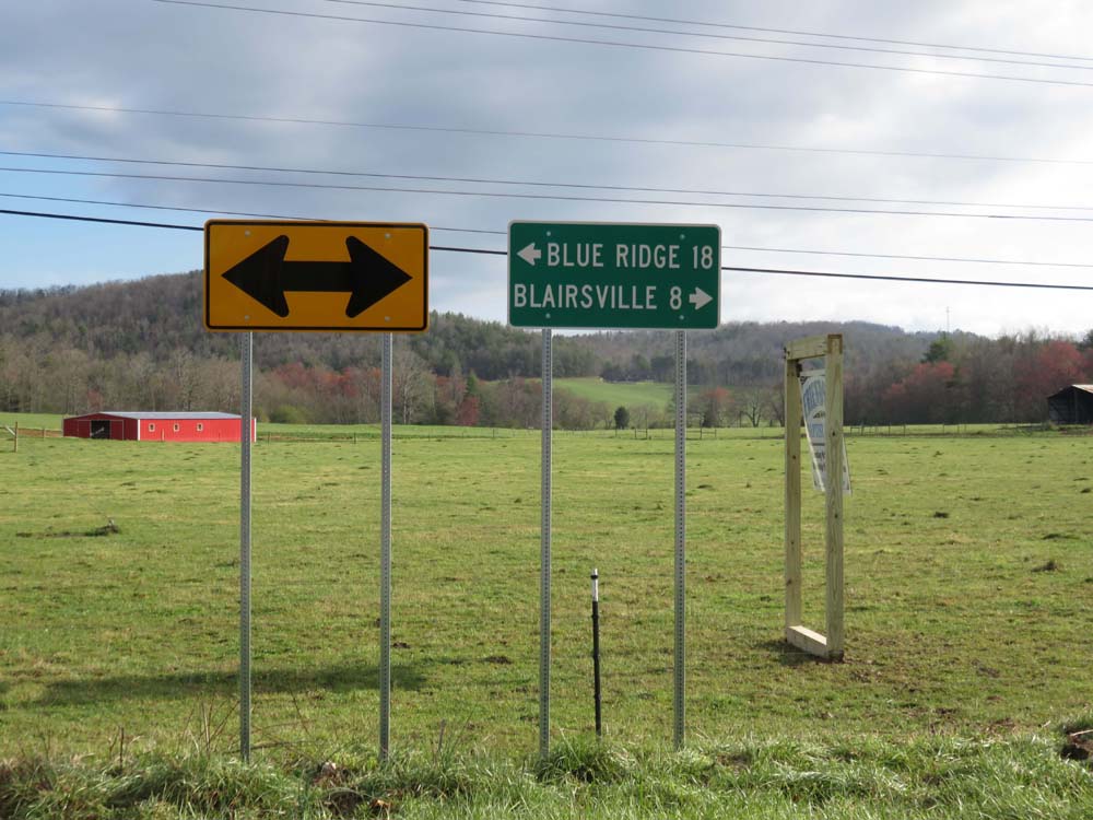
In the early 2000's this guide sign assembly was installed in Union County at Skeenah Gap Road and Old US 76.  This required outside involvement to get this engineered and installed since previously the arrow sign was deteriorated and no guide sign was present.  While the guide sign was not properly designed, it is closer to MUTCD compliance than the current sign.  The object markers next to the arrow are also a typical state practice.


Later it was determined that the mileage to Blue Ridge was incorrect.  This image shows how this could have been updated with proper routine maintenance provided through the state's traffic operations office and state-aid funding.  The 72" x 24" sign would have been corrected to proper specifications and dimensions, object markers replaced with MUTCD-correct design and double arrow likewise replaced with a correct standard sign.  This image, however, is a fake photo and this never happened.


Instead, the sign was replaced "as is" except the lengthy legend was squeezed into a 48" x 24" sign.  This sign is so skinny that it was impossible to make it MUTCD compliant plus the text height was reduced.  The object markers were removed per decision of the engineer.  While the sign on the left is correct, the sign on the right was an "as is" replacement with no effort put into properly designing the sign to MUTCD standards.  If this sign had not previously existed, it would not be here at all.

Even if local governments are entrusted to put up state-funded signs as they are in states like Virginia and Maryland, guide signs are more of a statewide issue.  Planning of guide signs requires an integrated approach where destinations that typically extend far beyond the local borders need to be identified with the best possible route.  The state also understands connectivity and roadway classifications better than the local agencies.  Thus, the duty to post any type of guide signs on roadways NOT maintained by the state should fall on the state or at least a statewide agency whose duties can be integrated to cover many counties and cities at once.  This means that guide signs should always be included in any budget for local sign maintenance in addition to inclusion in the federal-aid safety projects.  This also means that the duty to install these signs on any road should fall completely to the state or a regional highway agency with local governments focusing on street name signs.

Traffic studies are not always performed on these projects resulting in signs that, while MUTCD compliant in design, height and reflectivity are not properly engineered thus creating a greater hazard since they "appear" correct

Another major issue with the federal-aid safety programs is the fact that sign replacement projects often do not require an engineering study.  Much of the time, sign replacement work is "as is" meaning that no matter how many errors in judgment are made by the local government or how haphazard the sign work is, all signs are pretty much replaced as they were found.  Much of the funding used in both Georgia and Tennessee has included these "as is" replacements that replaced a sign that was substandard enough not to be trusted into a sign that "looks" official but is not correctly used.  This endangers the public more than the prior condition due to the expectation that the conditions shown on the sign line up with conditions along the road because the sign looks official.  Missing signs, incorrect curve signs such as "curve" used in a 90 degree turn and random sign work not backed by an engineering study is typical.  What's worse is that these agencies have used up their available funds and think the work is adequate meaning that these conditions will likely not be corrected for years.  This is not something that can be remedied when the work is transferred back to local control.  The state needs to be able to oversee spot treatments and thus be able to make corrections.  If a new curve sign requiring an advisory is posted incorrectly in one direction and not at all in the other, then the state will need to replace the signs on that post and put up a whole new sign in the other.  Maybe they can't fix the whole roadway, but they can certainly correct any discovered errors.


This scene along Blue Ridge Highway in Union County, GA demonstrates one of those errors.  While the sign is intending to say that the voting precinct is at the fire station, that is not the purpose of an emergency vehicle warning sign.  These signs should have been separated and likely never will since the state is currently not in a position to point out that this is not in compliance with the MUTCD.  Errors like this are not uncommon when a large number of changes are needed, and situations like this are "as is" replacements since this assembly existed in this fashion prior to this replacement.  While not the worst case, it shows that traffic control decisions should be a centralized to a level where it is engineer-driven and not a localized function.


The sign above "appears" correct due to post height, sign design and reflectivity being adequate, but this is in fact a significant and unfortunately common engineering error.  This is found on Gapland Road (a county-maintained road) in Frederick County, MD.

Local governments are under no obligation to either maintain to the same standards nor eventually replace these signs under another agreement.  They will do little to nothing if another state administered federal grant is not provided.

The idea behind the off-system safety projects is to aid local governments, not do the job for them.  When you aid somebody you do that under the expectation that they can handle the rest themselves.  The problem is that is rarely the case in terms of local traffic control, so aiding them in the form of a single project every few years is not a solution.  Since all but a couple states have anything near a state mandate in place, most local governments obviously are under no obligation to maintain what the state has provided in any form other than potential liability issues.  Georgia and Tennessee at present have no policy in place to regulate local agencies thus permitting them to do as they wish regardless of whether the local efforts reflect sound engineering practice.


Cowan Road Connector in Acworth, GA opened in 2001.  When it opened, all new signs were engineered correctly.  Unfortunately, this sign demonstrates that an improperly operated local agency can mess that up.  The "No Trucks" sign is not MUTCD compliant, added incorrectly under a warning sign and the warning sign itself is in need of its first replacement.  While the road was engineered correctly, including traffic signs, the city did not continue proper maintenance.  If the city had been under supervision of the state for traffic control, errors like this would not have happened.

Even if the work is done so beautifully that a county road is indistinguishable from a state highway when the signs are still brand new, the fact is that this once in awhile change in signs is not typically reflected by a change in local policy.  Local governments are not legally obligated to maintain what was given to them at the same levels as the state and without proper supervision will typically mess up what was done correctly the first time (such as adding speed limit signs under warning signs).  When signs go missing, get damaged or wear out, the only obligation the local agency is under is liability for causing an accident due to defective signs.  That is not enough of a deterrent considering that prosecution for engineering errors on a local level is rare.  While those circumstances sometimes are successful, usually the local governments prove more difficult to prosecute than the state making it very easy for them to successfully weasel out of situations like this or these problems would not be so common.  Most of the time older or missing signs either do not get replaced or replaced in the manner that they were first installed.  Sometimes conditions on the roads change such as a new subdivision or traffic operations change that is never corrected in the older signage.

This is where the state must step in and pursue measures that consolidate that responsibility to a statewide level.  Either the state DOT must begin to maintain this work for the local agencies or they (with the help of the state legislature) needs to help organize a statewide agency to do this instead.  They must also penalize local agencies who fall out of compliance if they do this work incorrectly on their own.  The original traffic studies should be held by both agencies, reviewed and periodically checked for compliance with modifications added for changing roadway conditions.  Standards should become uniform on all levels of government, and this function needs to be centralized to make sure that a qualified agency is always on top of traffic engineering.

Funding is not committed from a state level.  While there is (now) a state funding match (in Georgia), it is largely a federally-funded program

Of course, all the logic presented here still comes back to funding as well.  Neither the state nor the local governments want to take responsibility for funding this type of work.  Instead they point fingers, refuse to budget adequate amounts for traffic safety and thus are unwilling to take charge of the problem.  How can you rely on 159 counties and 538 cities in Georgia to consistently and reliably do the job correctly?  Likewise how can Tennessee residents depend on all 95 counties and 346 municipalities to do the job correctly?  The answer is that the state should not rely on any of them.  Instead, they should create either a single statewide agency or a few engineer-driven regional agencies that are able to do that for them.  They should then likewise dedicate a significant portion of state transportation funding to local traffic control relieving the counties and cities of that specific responsibility.  At present, neither Georgia nor Tennessee have dedicated any state transportation dollars to local safety work other than matching the funding for federal grants.


The signs in the image are all properly engineered and fully comply with MUTCD standards along Old TN 68 in Monroe County, TN.  This road, however, had its signs in horrible condition prior to this project with few warning signs and what was left old and incorrect.  The last time this road was state maintained was 1977-78 and many of the warning signs on that road dated back to that era.  The county has not changed its policies, so what is the realistic chance that the county will maintain these signs to the standards they were when first installed?  Slim.  This is where the state should be developing a means that traffic control is not directly supervised from a local level, especially on roads like this that are eligible for federal-aid upgrades.

If the states are not willing to otherwise maintain local roads, at least 1% of state highway funding should be set aside annually to finance operations of statewide or regional traffic control centers operating either as part of or independent of the state DOT.  Their duties would be to pool local resources from each local agency to properly plan, install and maintain traffic control devices on roads owned and maintained by local governments while the state pays for the engineers salaries, employees and facilities.  If any additional funding is available to fund traffic control on behalf of local governments in forms of federal-aid safety grants or state funding, this should be supervised by this agency not by the local government itself.  Otherwise, the local agencies would be paying into it.  That is what is described in the Traffic Control Cooperative Plan.  The state could also expand its capacity for local traffic control by swapping low-tech services with counties and cities such as winter maintenance, summer mowing/weed control, ditch clearing and pothole patching in turn for assisting local governments in sporadically installing, replacing and correcting traffic control.  Instead of paying a local agency to maintain roads on behalf of the state or vice versa, the state places the local agency in charge of specific maintenance activities in turn for equivalent payments primarily for local traffic control and traffic studies allowing funding to be adequate for most paved roads to have the majority of traffic control serviced by the state.  This is what is described in the Local Exchange Plan.

At the very least, having the state government expand its traffic control responsibility to roads they do not own such as collectors and arterials would be of great benefit meaning that these efforts would not be in vain.  If as-is replacements are full of errors, the state would still have good "bones" to work with in that all signs and posts in the field are to the most up-to-date standards and in good repair.  At the very least they could make some adjustments to work completed in projects and add to what is there if needed.

Federal funding in this program competes for other safety funding including on the state highway system meaning the funding could be stripped away from local governments to use exclusively on state-owned roads or used for purposes other than traffic control

Obviously state funding needs to be committed to maintenance as well as safety construction projects.  It is not enough to randomly do these projects then just leave them to each local agency to do what they want with.  At some point the state will need to develop a regional maintenance structure for this work to make sure it is done right, consistently and well.  There is no guarantee that the off-system safety funds will always be available or that they will continue to be used for this purpose, so better maintenance will mean that millions spent for traffic studies and upgrades that seldom happen will not be in vain.  Many competing needs exist as traffic volumes increase.  Because of this street signs, guardrails and traffic paint will always take a low priority next to more pressing roadway projects.  Thus, the state must eventually be committed to funding at least supervision of this service on behalf of local governments with or without federal-aid even if it means local governments are not making every decision.  That may even require a small tax increase to achieve, but it is worth it to provide safer, less cluttered and better maintained roads.

Local governments have broad powers to choose these projects and can decide against them if they do not want to maintain costlier compliant signage meaning that some local governments with the worst conditions deliberately opt out of the program

It should also be noted that these safety projects are not a blanket improvement.  Not all local agencies want to be stuck maintaining thousands of new street signs on roads where none existed before.  Perhaps they feel that the state's work oversigns their roads beyond what they can afford.  In Georgia's case, that may actually be true considering that the state has no policy in regards to curve warning signs in that many curves that do not pose a hazard nor require speed reduction that are signed.  The fact is that many local agencies have not signed on for these improvements on any significant level.  Instead, they choose to focus funding on road striping, as-is replacements, guardrail repairs or other improvements that present a lower cost to maintain and less demand.  If this is no longer their responsibility, then this will become less of an issue as an engineer-driven approach will mean that a balanced and cost-efficient approach will allow even the poorest counties to maximize use of their resources.  If a county has $10,000 to spend in one year and $500 the next, if that $10,000 is used only on fully compliant devices with the purchases pooled with that of many other local governments, it will stretch much further than if the county was paying for it themselves.  Most local governments would likely appreciate having an agency better equipped and more knowledgeable take care of roadway safety improvements as long as they retain regulatory authority to determine speed limits and vehicle restrictions on their own and have the financial muscle to make sure that their needs are being addressed.


A dangerous S-curve was improperly signed in Dawson County, GA after the county opted out of sign work for their county roads instead using the funding only for pavement markings.  This is a typical error with the curve misidentified (winding road) and instead of posting an advisory speed and chevrons they resulted to this redundant and useless sign.  The road here, Steve Tate Road, is a major collector meaning that it is potentially eligible to be a state route and carries according to GDOT state highway-level traffic yet the road is treated far less important.  

THE VIEW OF FEDERAL-AID SAFETY GRANTS OVERALL

Many will argue that this strategy is better than nothing being done at all, and they are right.  Many states refuse to delve into local matters at all, and the states taking even an indirect role in local traffic control is a huge improvement over the 1990's where state-aid in both states was limited to local paving projects and major construction.  Indeed, it is a step in the right direction and a continuation of even this program will have a lasting impact that will bring both state's local systems closer to full compliance.  However, it is still not an effective long-term strategy to bring an entire state into uniformity due to the fact that it does not actually correct the root of the problem.  Engineering problems will still exist, maintenance will still be inadequate and the majority of local government agencies will still not be qualified to handle traffic control matters by themselves.

The reason for this is that traffic control maintenance is not a touch and go strategy.  It requires an active approach that local agencies simply have not done well enough to be entrusted with.  While local control has many benefits, the cost to local governments for safety improvements is simply too high while the need is too low for it ever to take adequate priority.  Because of this, states as a whole, including the two state examples here, need to expand this program by funding regional traffic control cooperatives that not only place the authority for off-system safety projects under their jurisdiction, but also place maintenance authority for traffic control on local roads with them regardless of the level of funding provided by the local governments for that purpose.  States like North Carolina, Virginia and Delaware have demonstrated that even with tight budget constraints that a centralized strategy to traffic control is not only very effective but may actually reduce overall costs.  Likewise, it is not acceptable to place technical matters in the hands of a small local agency without any staff engineers or purchasing power with the expectation that this is something they will be able to handle well.  Such duties must be collectivized into larger units to be effective whether it be the state government or a statewide cooperative.  Overall, states are better trained, better organized and better able to absorb costs like this far more easily than a local agency that is sensitive to population, unit costs, politics, income levels of residents and capacity.

Monday, April 20, 2015

Curve Warning Signs: A Need For Better Federal Guidelines

One of the biggest problems with lack of uniformity in traffic sign application across the US has much to do with the inconsistent layout and maintenance of curve warning signs.  While a few states have more specific guidelines, the fact remains that the frequency of use of these types of signs and application varies from state to state and even more strongly varies on roads maintained by local governments.  Across much of the US, it is not uncommon to find few to no curve warning signs on local roads and streets regardless of terrain or traffic volumes.  Sometimes populous counties and municipalities do a terrible job while some less populous rural counties are more thorough.  What is worse is that there are a very high level of jurisdictions who post these signs without any proper engineering study done to determine their correct usage and locations.  This means that actually having these signs in place poses a greater risk to the driving public than if no signs were installed at all.


The list above shows most of the signs that need better nationwide standards.  Federal guidelines need to be expanded to push for not only greater state oversight but a more clear and consistent method of application that balances traffic volumes and funding.  

The rules when it comes to posting curve warning signs, chevrons and arrows are more clear than they once were but that has not exactly changed state and local practices everywhere.  Here are the typical rules for curve warning signs according to the most recent MUTCD:
  • Curves are supposed to be laid out so that curves/turns are marked as reverse curves/turns or winding roads if the distance between two or more alternating curves is less than 600'.  Note that this rule usually requires some flexibility in mountainous conditions where a winding road has one or more curves that is sharper than others in a series of curves or turns.  
  • Curve warning signs with advisory speed signs are mandatory when a curve or turn is determined to require traffic to slow 10 MPH or more below the posted speed limit to safely maneuver
  • Turn (W1-1) and Reverse Turn (W1-3) is supposed to be use when a curve has a posted advisory speed of 30 MPH or below.  Exceptions usually are noted on roads with already low speed limits such as roads posted 40 MPH or below.
  • Advisory speeds are also required to be determined using a ball bank reading, design speed equation (usually determined when a new road is being designed) or combination of ball bank meter and accelerometer.  The results of the advisory speed study determine if a curve should be signed and the type of curve sign to use (curve/reverse curve or turn/reverse turn).  The technology to determine advisory speeds has improved making this work easier and faster than in the past, but it is not being done consistently
  • Chevrons (W1-8) must be spaced evenly based on the advisory speed posted from beginning to end of the curve (a table describing the required distance between signs was added in the most recent MUTCD).  For instance, a curve with an advisory speed of 35 MPH requires 120' spacing.  
  • Chevrons may be posted only on the outside of a curve or turn.
  • Two chevrons must be in view in all times when mounted in a curve or turn from beginning to end of the condition.
  • Either chevrons or large arrow signs (W1-6) are mandatory on all curves and turns that have an advisory speed of 15 MPH or more below the posted speed limit.
  • A licensed civil engineer is required to either oversee or conduct studies to determine locations of all curve warning, chevron and arrow signs (in addition to other signs).
Typically these are the common engineering deficiencies related to each point listed above:
  • Improper Usage:
    • Reverse curve/turn and winding road signs installed when distance between two or more curves or turns well exceeds 600'
    • Curve or turn instead of reverse curve or reverse turn used when distance between curves is under 600' (sometimes on each curve)
    • Use of W1-2 curve instead of W1-1 turn for a 90 degree or acute angle turn when speed limit is above 30 MPH presenting a special hazard to motorists who may not notice the lower advisory speed due to suggestion the curve is less sharp than it is.
  • Lack/Excess of Curve Signs:
    • Curve warning signs are not posted at all when a curve requires slowing to 10 MPH less than the posted speed limit
    • Curve warning signs are posted when a curve is too gentle to require any signing and/or speed reduction.
    • Inconsistent application is not uncommon: especially when knockdowns are not replaced
    • Lack of documentation of curve sign locations meaning signs are forgotten about
  • Improper Advisory Speed Study:
    • Advisory speeds are frequently "determined" using methods that are based on nothing more than field observation by non-engineers or untrained technicians.  
    • This involves basically just driving the curve and getting a "feel" for the curve.
    • These non-technical measurements are likely to lead to incorrect advisory speeds creating a hazardous situation for motorists, because one employee might "feel" that a very slow speed is a safe speed for a curve while another "feels" that a much higher speed is safe.
    • The variation in field observation based on "feel" will lead to drivers ignoring underposted advisory speeds while excessively high advisory speeds can cause a vehicle to leave the road.
  • Incorrect Posting of Chevrons/Arrows:
    • Chevrons are often posted in a manner not conducive to MUTCD standards such as posting them in the fashion of arrow signs, posting only one in a curve or turn or posting them in clusters on only one part of the curve.
    • Chevrons used where object markers or diamonds are required
    • W1-6 arrows used improperly in the fashion of chevrons
  • Lack of Supplemental Required Chevrons/Arrows
    • Many, many curves and turns with advisory speeds 15 MPH or more below the posted speed limit lack any chevrons or arrows
    • No prior speed reduction with W3-5 and R2-1 to adjust speed limit in hazardous curve area so that chevrons/arrows are not required when advisory speed is otherwise 15 MPH or more below the typical speed of the roadway
  • Lack of Staffing on a Local Level for Curve Sign Studies
    • Most local agencies lack the resources to hire, even as a consultant, a licensed traffic engineer just to conduct traffic sign studies.
    • While the state may assist in this matter in state or federal-aid projects, there is nobody on the local staff properly trained to identify and correct errors or conduct traffic studies.
    • States will not provide traffic studies for the local governments without charging as much as a private consultant
    • This is how these errors become common.  Some states do have state-funded county engineers, but this is no guarantee that the county engineer is actually handling traffic control matters as evidenced by the prior post about Morgan County, AL.  


This curve sign marks a 90 degree turn on Cox Street in Eden, NC.  A city-maintained street, the city has posted an incorrect advisory speed sign, a curve sign instead of a W1-1 turn sign and no large arrow in the turn despite the road ending straight ahead.   This highlights common engineering deficiencies on a local level.  (Aerial image from Google Maps).

Laying out a proper curve warning sign plan is the most technical work in traffic control proving to be even more complicated than guide and route sign assemblies especially when working in mountainous conditions.  In addition, maintenance management of such signs is difficult.  Here is what is typically required to maintain these signs:
  • Data and Documentation:
    • Extensive documentation must be kept of sign plans with a dedicated replacement program to identify and replace worn out signs, stolen signs and knockdowns [records kept by transportation agency]
    • A GPS database is needed showing sign locations, identifying their condition, age, location and MUTCD sign ID's
  • Traffic Studies:
    • Every public road, not just state roads, are supposed to have a traffic study conducted by a licensed traffic engineer with a traffic engineer thus overseeing work after sign projects are completed to make sure that signs remain consistent, none are missing and all meet MUTCD standards
    • Few local agencies have this or can afford to have a dedicated traffic operations unit headed by a PTOE to make sure this is done
  • Engineering Errors:
    • Care must be taken to correct engineering mistakes such as signs placed in the wrong location, the wrong sign used or signs that were not identified in traffic studies (e.g curve posted in only one direction)
    • These errors typically require someone with special knowledge on how to identify these errors meaning either state traffic operations must have supervisory authority on local roads or a regionally-funded PTOE must be hired full time to oversee roadways otherwise maintained by multiple local agencies since a single local agency lacks the resources for this
  • Attention to Accuracy and Detail:
    • Signs should be replaced correctly so that a W1-4 reverse curve sign is replaced with just that and not a W1-3 reverse turn or W1-2 curve sign
  • Speeds Must be Accurate and Safety-Based
    • Advisory speeds must be set correctly based on proper engineering studies
    • To avoid excessive use of signs on very winding roads, speed limits should be adjusted lower in areas where an unusually high amount of curve warning and chevron signs would be required otherwise  
  • Deferment of Traffic Control Supervision to a Larger Agency:
    • A local agency that lacks a staff engineer or its own traffic operations unit should be able to defer that responsibility to the state DOT or partner with other cities/counties in the region for that purpose, but this rarely happens.  Note that the MUTCD recommends the latter.
    • The first calls for state contracting, which most states refuse to provide to local governments while the second calls for regional services which are not available in most states.
WHY THESE SITUATIONS WITH INCORRECT CURVE WARNING SIGNS ARE SO FREQUENT

Local governments clearly have the most difficult time properly managing a curve warning sign program, but even states have difficultly managing this work despite having multiple engineers and years of experience available to handle this task.  Part of this is due to the cost of this work and the fact that non-engineers are typically not allowed to perform these operations on their own.  A lack of a certified traffic control technician as a legal position has hampered the ability to address issues on miles of local roads due to the shortage of qualified engineers available to do this work.  County and municipal engineers usually need trained assistants or traffic operations units to help them with the management of this work since a county engineer's load is usually too heavy to properly oversee day-to-day traffic operations.  This is why more than likely this work falls on an employee without adequate training or any certification to handle traffic operations.  Anybody that works in traffic operations should be required to enter an intense training program taught as a year-long course.

After the creation of this field, only civil engineers with the PTOE certification or licensed traffic control technicians will be permitted to do this work with nobody else permitted to plan, design or install traffic control devices.  Obviously, the licensed traffic control technician (LTCT) will have some limitations in that they will not be permitted to design larger structures such as sign bridges or any other overhead structure, but otherwise they should be capable of handling those responsibilities on condition that they are able to handle the math requirements.  The license means that like an engineer they would be personally liable for not following proper engineering protocol.  Breaking off this work from civil engineers placing the responsibility on a licensed non-engineer would make sense as a way of lowering the cost and raising the output thus raising standards.  By doing this it would be possible for traffic control operations to be overseen by someone whose entire position involves collecting data, analyzing data, creating sign plans and then using a GIS database to store the records of that work with a legal requirement that is as binding as it is for the PTOE.  A licensed traffic control technician would work under direct or indirect supervision of a PTOE and would typically still require a civil engineer to review all work plans.  If working for a local government without an engineer on staff, the LTCT would be under supervision of the state's district engineer.

Overall, the extremely high amount of situations where this work is non-existent or incorrect shows how difficult this is to manage and is a major reason why State and Local Road Reform believes that most local governments are not well suited to handle the engineering and maintenance of traffic signs independent of a state agency or regional government unit.  One of those reasons is because local governments were largely laid out based on antiquated principles, especially county and township government.  The layout of most counties, small towns and townships was not done with any consideration of the high costs and organizational structure needed to meet modern transportation demands.  Modern transportation demands cannot be effectively met without high economies of scale, people who know what they are doing and the benefit of adequate tax bases: both usually well above what the typical county or municipality can provide.

In addition, the author believes that states need a better policy to handle this work.  Some or even most states do not have a written policy on how to manage the installation and maintenance of curve warning signs.  This leads to situations where roads are oversigned well above the level of risks present or traffic volumes.  Many situations exist where curve signs are posted in places where sight distance is clear and no speed reduction is required even if the driver is 5-10 MPH above the posted speed limit.  Those resources could be better distributed to other sign needs if sign clutter like this is removed.  In fact, the only instance where signing a gentle curve makes sense is where a very straight road has a bend that requires driving at a speed 0-5 MPH below the speed limit, which is typically not high to require an advisory speed.  Otherwise, it not only diminishes the importance of other signs while making maintenance more difficult and costly, but also it becomes less likely that the truly dangerous curves are properly identified both by highway agencies and motorists.  For instance, a W1-5 winding road sign might be posted for a situation where one curve requires no speed reduction while two other curves are sharp turns requiring a speed drop to 20 MPH below the posted speed limit.  A driver might not take the situation as seriously seeing a gentle curve, take the first curve fast and then crash on the second curve.  Similarly if a series of curves are signed that do not require any speed reduction then a driver is less likely to notice signs posted for a curve that require slowing down to safely navigate.  

THE SOLUTION ON A FEDERAL LEVEL

Further in this post a plan will be described that details how roadway classifications, traffic volumes and overall functions should be added to the MUTCD as a means of correcting extremes in curve warning sign policy ranging from too many signs to not enough signs.  Overall, the federal government needs to be a better steward of traffic sign policy on both a state and local level.  While the federal government does not have an iron clad way of policing bad traffic sign engineering practice, they should begin to hold states liable for this work not only on the state's own road system but also the local road system.  If the state has not developed an effective strategy to permanently correct traffic control deficiencies including curve warning signs on local roads bringing them in substantial uniformity with MUTCD standards, then this will need to change.  While all signs need to be in substantial compliance, focus is badly needed on proper curve warning sign engineering.  Since the public and many states do not recognize the importance and technical nuances involved in this type of work, the federal government needs to have more authority in this area.

The best way to do this is to define safety improvements as a substantial amount of federal-aid given to states.  Currently the federal government has some limited funding for this program, but it may be necessary for the federal government to begin to primarily fund traffic control devices to assure that states and local governments are installing and maintaining these devices correctly.  Funding would be distributed to states to be divided between the state and local governments for traffic control devices.  This funding, however, will be based on ratios of state control.  This means if a state has 10% under state control and 90% under local control, then the state must spend 90% on local roads and 10% on state roads.  Using the ratio method assures that states do not feel pressured to transfer roads to local governments as a means of raising and distributing funding.  The ratio simply changes with the level of state control.  This also puts less pressure on states to finance traffic safety work entirely on their own.

However, this federal funding must come with a catch.  The federal funding to be used on local roads may not be distributed directly to local governments.  It must be handled exclusively by state agencies and engineered through either state forces or private engineering firms hired by the state.  Signs used on local roads must be purchased through state-approved private vendors and meet state standards with the states becoming liable for not just installation but also maintenance of these signs on local roads as long as federal funding is provided for continued maintenance.  While the entire duty for traffic signs will not fall on the state governments, this new responsibility will require that state governments require local governments to meet the same specifications on anything they install thus creating a mechanism that states police local governments or else they will be required to handle that responsibility for local governments.  This federal funding clause will also force local governments to organize traffic control cooperatives with other counties and cities as a way to properly finance and supervise traffic control when today the federal government generally ignores local government actions.  Either way, the funding should be at a level to assure that local governments who are incapable of providing technical services on their own are provided a means to pool resources to either the state or regional level.  States that fail to properly manage this federally-funded work for local governments and follow MUTCD standards will also risk losing all federal funding unless conditions are met to acceptable federal guidelines.

On federally-maintained roads and roads in the District of Columbia, a slightly different approach should be taken where one of three things occurs:

  1. DC contracts traffic control with an adjoining state or neighboring local jurisdictions to form a larger regional body that includes parts of adjoining states.
  2. Authority for traffic control shifts to the US Army Corps of Engineers
  3. Authority shifts to another federal agency that can oversee this work in a manner similar to a state government.


THE SOLUTION ON A STATE LEVEL

A federal solution is not necessary if state governments take the initiative to handle this responsibility correctly on their own.  The solution for a poorly executed curve warning sign policy will require that states take one of two approaches:


  1. A Contracting Approach
    • States select individual roads annually in every county (or entire counties) for a review.  They  hire a private engineering firm to study these individual roads, including both state and local roads, to determine where there are missing signs (also including intersection warning signs) and to identify that hazardous curves and turns that require speed reduction
    • The state will either provide funding to the local agencies to install the signs according to the study or provide the results expecting the local government to fund the install based on the review within a 2 year span
  2. A Consolidation Approach
    • This involves the frequently discussed approach of using state forces or special regional cooperatives to provide this service on behalf of the local governments so that all errors and emissions can gradually be identified and corrected
    • The consolidation approach includes routine maintenance while the contracting approach requires periodic projects and updating of prior work to occur at least once every 10-15 years


Either approach will require sweeping reforms, and the cost of upgrades will be costly.  The consolidation approach will not increase costs, but for conditions to improve in a shorter time frame additional funding will be required.  The contracting approach, however, will require a significant annual investment from both state and federal funding.  Using these findings this means that at the very least many existing curve warning signs will need to be:

  1. Modified if information is correct, but is displayed in a non-standard way
    • e.g. R2-1 used instead of W13-1
  2. Removed to reduce clutter if signs are excessive
  3. Corrected if existing condition is wrong or outdated
    • curve used where reverse curve is needed
    • modify existing W1-2 and or W1-4 to W1-10 signs for intersections found in curves
    • 24" curve signs used
  4. Installed if signs that are needed are missing
    • curve posted in one direction, but not the other
    • chevrons/arrows are needed in curve
    • sign locations are identified in studies, but none in the field

By removing excessive signs from the roadway, the state or local government will be able to better finance the signs that they have while promote safer driving conditions.  This is because hazards on the roadway will become more readily noticeable because the number of signs will not overwhelm the driver.  It should also be noted that these state roads refer primarily to roadways in states where fewer than 20% of the road network is under jurisdiction of the state government.  In states with larger state road systems, the lesser secondary routes should be reviewed based on roadway conditions and functional classification for the purpose of better distributing state resources in regards to curve warning signs.  

THE SOLUTION ON A LOCAL LEVEL

It was stated earlier how the local conditions are far more serious than those on the state roads, but the need for curve warning signs is very different from state highways.  Most state highway systems carry higher functional classifications in addition to the bulk of traffic while local roadways usually only carry heavier traffic in either more populous areas or on longer rural collector roads that are not otherwise maintained by the state.  Other local roads are often shorter, carry less traffic and often do not serve through traffic.  Regardless, the fact that local conditions vary means that it is far more difficult for local governments to properly budget and develop an effective curve warning sign program when they are responsible for a far higher percentage of roadways of all different classifications.

With no clear rules on the best approach based on traffic volumes, roadway characteristics and speeds, to a local agency it appears that every winding road and sharp corner needs curve warning signs when the budget for that work is simply not there.  The result is that local governments typically either neglect the issue or take a very half-hearted approach.  These are the questions a local government often might ask themselves:

  • Should we install more signs than they can afford to maintain or do they take a modest approach and leave most roads void of any curve warning signs?
  • Should we install and maintain signs well below MUTCD standards because having anything there is better than nothing at all?
  • We are a mountainous area, so should we post any curve warning signs at all?  
  • We don't have the money for traffic studies, so should we just randomly post winding road signs on mountainous roads?
  • Should we only post a curve sign where a previous accident occurred?
  • Should we spend a million to fix every sign when there is no way we can afford to maintain that many signs?  

This is how most rural roads in many states ended up with few to no curve warning signs at all while curve warning signs issued through state-aid roadway projects during the 1960's and 70's ultimately were left to rot by those same local governments within those same states states.  This is especially true in those cases where small, low population local agencies were in charge.

No matter how that question is answered, the truth is that on a local level that local governments typically have not been consistently successful at handling curve warning signs.  Many avoid any corrective action fearing high costs and greater liability to maintain a high cost sign maintenance program even when terrain is flat enough and roadways are straight enough that the cost is far more manageable.  When budgets are primarily only large enough to post stop signs and a few street name signs every year, an investment in thousands of warning signs that did not exist before on roads that do not carry state highway traffic is not a popular idea.  Instead of hiring a traffic engineering firm to help correct deficiencies, these local governments often rely on in-house employees with little to no actual experience with that line of work.  A more dedicated employee given a larger budget might do a better job, but the evidence that no traffic study was ever undertaken is evidenced by common errors similar to the list of engineering deficiencies above.  Below are some examples with photos: 
  • Incorrect curve sign used (e.g. posting W1-2 curve signs with no advisory speed for sharp 90 degree turns where a W1-1 is required)

Leman Rd eastbound at JE Waters Rd in Emanuel County, GA has this incorrect curve sign posted in the advance of a sharp 90 degree turn.  While the signs were state funded it is unclear who is responsible for this engineering error.  (Photo from Google Street View, March 2014)
  • No advisory speeds posted on any curve signs

    S Cedar Cove Road meets N Cedar Cove Road in Morgan County, AL at a 135 degree turn.  This turn sign includes no advisory speed to indicate how fast this turn should be taken.  (Photo from Google Street View, June 2014)
    • R2-1 speed limit signs used to indicate advisory speed where W13-1 signs are supposed to be used

    Old Federal Road in Murray County, GA (since corrected via an off-system safety grant) has speed limit signs used in place of advisory speeds.  It is unclear whether that is the actual speed limit or the advisory speed for the curve when this is done.


    Old TN 68 in Sweetwater, TN features another instance of this practice.  Is the speed limit 20 MPH or do I need to slow to 20 MPH for the curve?
    • No identification nor replacement of missing curve signs

    Welty Church Rd in Washington County, MD is posted at 35 MPH but includes this S-curve that has no advance warning that likely requires a 10 MPH speed reduction.  (Photo from Google Street View)
    • Incorrect advance placement distances (sign too close or far from condition)

    This curve sign in Floyd County, GA has no advanced warning.  Also note the chevron signs on the incorrect side of the roadway.
    • Non-compliant devices (e.g. incorrect design or dimensions)

    This winding road sign and advisory sign violates MUTCD standards in every way.  The dimensions of the winding road symbol are wrong and the advisory speed plate has both incorrect fonts and incorrect dimensions.  This is found on Old US 441 northbound in Rabun County, GA.
    • Improper use of signs (e.g. "Dangerous Curve Ahead")

    Although later corrected with a state grant, this sign was used to mark a sharp turn in Fannin County, GA in the late 1990's.


    This sign was discovered last fall on Steve Tate Road in Dawson County, GA.  The winding road sign in the background is also incorrect and too close to the curve.  It is actually a reverse curve/turn.  This sign is useless and should be replaced with the proper curve sign and advisory.
    • Incorrect chevron placement (e.g. chevrons do not follow through on curve, chevrons are on wrong side of the road or only one chevron is posted in a curve)

    This curve on Edgemont Road north of Mong Road in Washington County, MD has incorrect chevron placement.  Note that while "two are in view" they do not follow through from beginning to end of curve.  Note the two chevrons in the opposite direction.  (Photo from Google Street View, September 2012). 
    • No chevrons or arrows posted at all in a curve that requires a speed reduction of 15 MPH or greater from the posted speed limit
    • Signs are dirty, old or not mounted correctly

    Misty Meadow Road northbound north of Watery Lane in Washington County, MD has a very old and worn out reverse turn sign (Photo from Google Street View, August 2012).


    Stinking Creek Road in Campbell County, TN is a typical example of a rural county with no budget for curve warning signs.  Most curve signs posted on this road were installed when the road was originally paved by the state.  All but a few are gone including this arrow sign above and reverse curve sign.  (Photos from Google Street View, April 2014).

    The issues above are not uncommon.  Because of this, correcting curve sign deficiencies on a local level will require a top down approach that expands beyond single state-aid sign projects.  Traffic sign studies are prone to errors and omissions that go unnoticed while most local agencies are not equipped to maintain a larger number of traffic signs.  Unfortunately, most rural governments are not going to fund either the installation or maintenance of this kind of effort on their own.  

    Obviously the best approach for maintenance is to transfer traffic sign engineering and maintenance of all warning signs, but especially curve warning signs, either to the state or to statewide regional engineering districts to handle this duty.  It is also important to create a method of signing these roads based on actual need.  A functionally-local, low speed, low volume rural road in a mountainous area is not going to need to have 500 curve warning signs, chevrons and arrows when the budget is not sufficient to allow it and a lower speed limit or the identification of a few particularly hazardous curves would be sufficient.  In many cases it would be best to have nothing at all.  When far too many signs are in place, the ones most likely to find these signs useful on very lightly traveled roads are vandals who will steal them, use them for target practice and/or spray paint profanities while local or state authorities will likely forget they are even there.

    These unnecessary signs create a greater liability to whatever agency is in charge of that road.  Setting the speed limit to reflect conditions would be a far less costly strategy or simply adopting a "drive at your own risk" strategy posting a sign like "No Curve Warning Signs" with a plaque reading "Next X Miles". Inversely, this does not justify setting speed limits artificially low just to avoid posting curve signs.  Speed limits should be set based on either roadway characteristics (majority of curves cannot be safety driven over 35 MPH) or prevailing travel speed.  This means posting an arrow straight two mile long rural road at 25 MPH just because of a single 90 degree turn halfway through is not the intent of this policy.  Likewise, residential streets, unpaved roads and low speed roads do not need the same investment in curve warning devices that roads with higher speeds require.


    A "No Curve Warning Signs" sign could be adopted by either the states in their own MUTCD supplement or the federal MUTCD as a means of alerting motorists that they are on a lightly traveled road whose traffic volumes are too low to dictate the use of curve signs and thus must be alert for alignment changes that are not warned.  This sign should be used with a "NEXT X MILES" plaque.

    However, a major collector road with low traffic volumes and a 35 MPH-55 MPH speed limit presents a different situation.  There is a potential of non-local traffic, higher speeds are present and the likelihood of hazardous conditions will require longer reaction time.  With roads like this typically better constructed, they are less likely to be oversigned yet still have a higher risk of accidents due to wildlife entering the roadway, traffic entering from hidden driveways, different roadway conditions (e.g. lack of shoulders or narrow lanes), less light during evening and nighttime hours and a lower expectation by drivers of encountering other vehicles.  Obviously driver error due to poorly engineered or maintained curve warning signs is also a frequent factor in these accidents as drivers leave the roadway due to inadequate or incorrect information.  Since speed limits are often statutory and not actually based on design speed or conditions, it is important that curve warning signs are consistent, uniform in practice and accurately display the needed information to help drivers adjust their speed for hazardous conditions.  

    The table below lays out a curve warning sign plan.  This is a suggested method to use, regardless of jurisdiction, where a state or regional agency dictates how and where curve signs are laid out as a means of keeping consistent, uniform and well-maintained curve warning signs on the roads where they are the most needed.  This will also make it easier for states to develop a strategy to aid local governments.  


    The table above describes the conditions that should be considered for curve warning signs designed to unify curve warning sign standards nationwide across multiple jurisdictions and states.  At present there is no uniform approach taken from state to state.

    OVERALL CRITERIA FOR THE NEW CURVE WARNING SIGN POLICY

    The table above shows the new method proposed for determining curve warning sign locations along roadways based on the criteria of functional classification, traffic volumes (using population density when traffic counts are not available), posted speed limit and roadway surface (paved/unpaved).  This policy dictates that curve warning signs are placed on roadways based on actual need regardless of ownership.  Thus, drivers will come to expect that a roadway that lacks these signs is smaller, more lightly traveled road while a roadway that has these signs is a through road or has heavier traffic.  States can then set budgets more effectively to determine the amount of resources needed to cover traffic control devices while local governments will be more willing to work with states if their resources for warning signs are concentrated on roads that carry higher traffic volumes or are more important.

    Creating an environment where more qualified employees exist to address traffic control needs would be helpful to improve curve warning signs as well as traffic signs everywhere.  The current model of restricting this work to licensed civil engineers is clearly not effective given that most agencies cannot afford the cost required to hire a full-time engineer or engineering firm to do this work nor are the available engineers able to budget adequate time to this type of work.  A licensed traffic control technician could help to focus efforts on an employee whose primary task is to handle traffic control work requiring a lower cost to hire than a civil engineer.  This would help to bring more employees into the field with the knowledge and expertise to properly recognize, design, correct and install traffic control devices.  

    Obviously, this policy should be coupled with the strategies presented on this site.  States need to not only reform their own policies but also preferably take over traffic control engineering duties for local governments unless a regional multi-jurisdictional regional structure can be adopted.  No matter what method is adopted, the typical local agency lacks the financial capabilities to properly oversee or fund this type of work and it is shown by the inconsistency and the enormous amount of errors in regards to curve warning signs.  Such a program would be far easier to execute if states would not blindly assume that local governments that are already not doing an acceptable job are going to follow the recommendations above unless they do this themselves.  This will, however, help states to better manage available state and federal-aid funds by concentrating funds on qualifying roads while not wasting resources on unnecessary signs.  

    Three plans proposed would help to easily steer resources to cover the cost of correcting and maintaining warning signs as part of a uniform policy on both state and locally-owned roads.  They are:


    • Traffic Operations Cooperative Plan
      • This engineer-driven approach creates the ideal conditions for unifying standards and creating uniform policy by removing primary responsibility for traffic control from the local agencies and transferring it to regional cooperatives or the state DOT
    • Two-Way Consolidated Road Maintenance Plan
      • This plan creates conditions where local control of traffic control is limited only to local agencies with the population and resources to adopt this strategy with additional heavy state-aid funds while entrusting the state DOT or regional cooperatives to handle all of the other roads across the state
    • Local Exchange Plan
      • This plan frees up resources available on the state level to gradually chip away at traffic control deficiencies by allowing the state to transfer resources typically used for labor-intensive maintenance work to technical work thus allowing the state to make incremental changes based on state DOT policy, which would likely include this new curve sign policy


    However, state agencies can only do so much.  The only way to assure a uniform and effective strategy to correct the currently ineffective curve warning sign methods is to create a more detailed nationwide policy that better explains to states and local agencies how to prioritize the installation and maintenance of warning signs.  They can, of course, exceed these standards but this approach provides the best balance for resources between urban and rural areas while preventing roads that are sparsely traveled from being oversigned.